Plotting Aotearoa New Zealand - How We Made our Maps
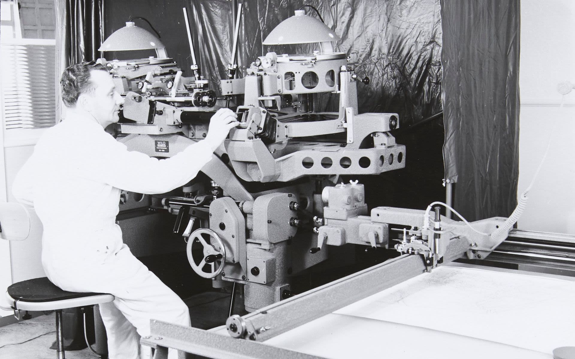
Mapping a country does more than help drivers and hikers navigate their way from point A to point B. Cadastral maps for example demarcate property boundaries, and topographical maps provide detailed information about the contours of the terrain and assist in planning urban developments and roading.
Producing maps of a country like Aotearoa New Zealand, with its mountains and dense bush-covered valleys, is a long and arduous task using land-based surveying methods. Taking to the air with aerial cameras installed in aircraft allowed easier access to Aotearoa New Zealand’s often rugged terrain for topographical mapping.
In 1935 the New Zealand Government, having recognised aerial surveying as the most economical approach to mapping Aotearoa New Zealand, established a National Mapping Committee under the Organisation for National Security. With much of the country not easily accessible by road and limited topographical maps available, a coordinated approach to mapping was needed.
New Zealand Aerial Mapping (NZAM) became a contractor to the government in 1937, and the Wild A8 stereoplotter in MOTAT’s collection was used by NZAM for several decades to convert vertical aerial photographs, taken by aerial cameras mounted in the company’s planes, into maps.
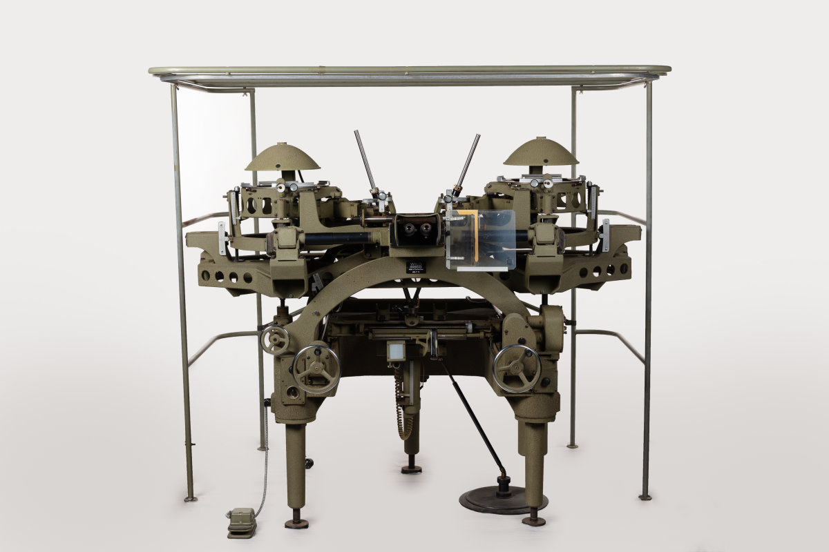
Wild Heerbrugg A8 725 Stereoplotter [2020.9.1] The Museum of Transport and Technology (MOTAT).
Photogrammetry is the science and technology of deriving information about the whenua (land) and its built features from the interpretation of photographs. Developed around 150 years ago, photogrammetry was initially an analogue technique, in line with the technologies of the day. Today it has moved squarely into the digital although the concepts and principles that underlie photogrammetry have remained constant.
Geometry and mathematics underpin its core practice, which uses triangulation to make measurements of three-dimensional objects or landscape features from two-dimensional photographs. Aerial photographs taken vertically with a 60% overlap produce, when overlaid, a three-dimensional image. When the paired images are viewed through a stereoplotter, the operator, or photogrammetrist, works with notes and field data from land surveyors as controls to make measurements from the three-dimensional image. An application of photogrammetry is the making of accurate topographical maps, and the Wild Heerbrugg A8 725 stereoplotter in the MOTAT collection was used at NZAM for this purpose.
Before 1935, most aerial surveying of Aotearoa had been undertaken by the Royal New Zealand Air Force, then the New Zealand Permanent Air Force. This was a common approach internationally as aerial mapping developed from the military’s desire for knowledge of the terrain and its features for reconnaissance.
The Swiss company that manufactured MOTAT’s stereoplotter, Wild Heerbrugg, became a key player in the development of both aerial cameras and plotting equipment due to Switzerland’s need to map its inaccessible mountain terrain by air. In New Zealand, the Air Force purchased its first aerial cameras in 1925 and established an aerial mapping unit by 1936.
The Lands and Survey Department began using Barr and Stroud topographical stereoscopes in 1935 to produce topographical maps from the Air Force’s aerial photographs. The first topographical map to result from the new coordinated approach was published by the Department in 1939.
New Zealand National Film Unit presents New Zealand Mirror No. 21 (1953) Including: MAPS FROM THE AIR. 180 ft. The New Zealand Aerial Mapping Company's plane at work over the Rotorua district, followed by the preparation of photographic mosaics and maps.
In 1937 New Zealand Aerial Mapping, founded by Piet van Asch in Hastings only a year earlier, received its first contract to undertake aerial surveying for the government. In the few years after NZAM was founded, the RNZAF suspended its aerial mapping programme due to the outbreak of the Second World War and NZAM became the main government contractor, eventually dominating the industry in New Zealand for the next 50 or so years.
Initially, NZAM produced photographic mosaics and it was not until 1953 that the company hired a photogrammetrist and acquired its first stereoplotter, a war surplus Multiplex purchased from Canada. Until this time only the Department of Lands and Survey had the equipment and expertise to produce topographical maps from aerial photographs. NZAM, now equipped with an aircraft, cameras and photography department, and a plotter, was able to undertake the full process of aerial mapping.
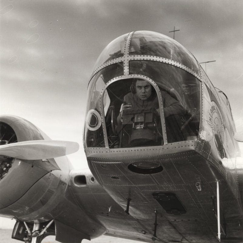
“Beechcraft AHO – nose and camera” Book 31A (Technical only) [ALB-2018-7] Museum of Transport and Technology (MOTAT).
With the purchase of three Wild A8s in 1959, NZAM’s share of work and contribution to the topographical mapping of New Zealand increased significantly. Wild’s A8 plotter was newly designed and a distinct improvement in speed and accuracy on NZAM’s aging Multiplex stereoplotters. Where the Multiplex plotters required the operator to work in a dark room, the A8 brought the operator into the daylight; the improved technology thereby also created a vast improvement in terms of the working environment.
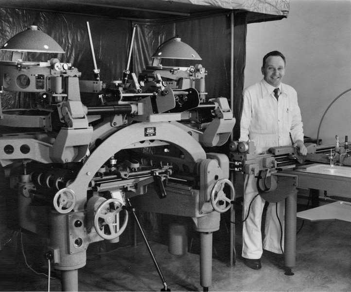
“A great step forward on the earlier Multiplex plotters, this first order A8 stereo plotter from the stable of Wild is shown being assembled at NZAM in Hastings by Swiss engineer Joe Bruilhart.” Image courtesy of Knowledge Bank Hawke’s Bay Digital Trust Archive. This work is licensed under a Attribution-NonCommercial 3.0 New Zealand (CC BY-NC 3.0 NZ).
At the time the A8s were purchased, NZAM was flying the Beechcraft AT-11 Kansan also now in MOTAT’s collection and using Wild aerial cameras installed in the nose of the plane. Hundreds of photos were taken on each surveying flight by the Wild cameras, later replaced by Zeiss cameras as their technology improved. The plane flew in survey lines that created a 60% overlap in the photographs of the terrain below to provide the stereovision needed for the stereoplotter. NZAM’s photography department created diapositives - positive photographic images on a transparent base - from the film that came out of the aerial camera.
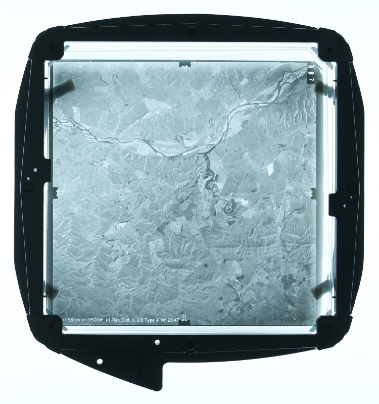
Illuminated diapositive in picture carrier [PHO-2020-9.1] Museum of Transport and Technology (MOTAT).
The stereoplotter operator uses the plotter and a connected plotting table to convert the aerial survey photographs into topographical maps. Pairs of diapositives are introduced to the plotter, one on each of the picture carriers on either side of the A8, each of the same area, with one overlapping the other. The diapositives are illuminated by lamps suspended above the picture carriers. Only a small portion of each image is used due to distortion at the edges of the images. The machine uses prisms to bring the two images together in the operator’s optics or eyepieces. As the operator views the images simultaneously, they see a three-dimensional view of the ground.
While the A8 provided a high level of accuracy, the operator also needed stereoscopic acuity as well as a high level of training. The stereoplotter operator needed, for example, to set the machine to known survey heights, a process which could itself take between two and four hours. Using handwheels on the A8 and a floating reference mark visible over the images, the operator plots the photographed area on the connected plotting table, starting with simple features like roads that break up the area and working down into more detailed features of the terrain.
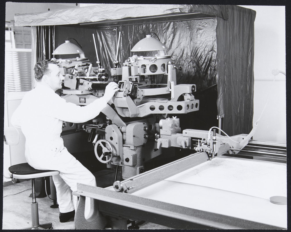
“Old Wild A8 Stereoplotter” Book no. 31A (Technical only) [ALB-2018-7] The Museum of Transport and Technology (MOTAT).
The three Wild A8 stereoplotters were used at NZAM for many years to create topographical maps from the aerial photographs taken by the company’s planes. In 1984 an analytical stereo plotter, the BC1, was purchased from Wild to replace the aging A8s, as NZAM upgraded from the A8’s analogue technology to digital technology. The other two A8s were sold to buyers in Japan and the parts were re-purposed into digital machines. MOTAT’s A8 remained in use part-time until it was purchased from NZAM in 1997 by a former employee of the company and who used it until 2017 to make topographical maps for private clients, in particular the Hawke’s Bay Orienteering Club.
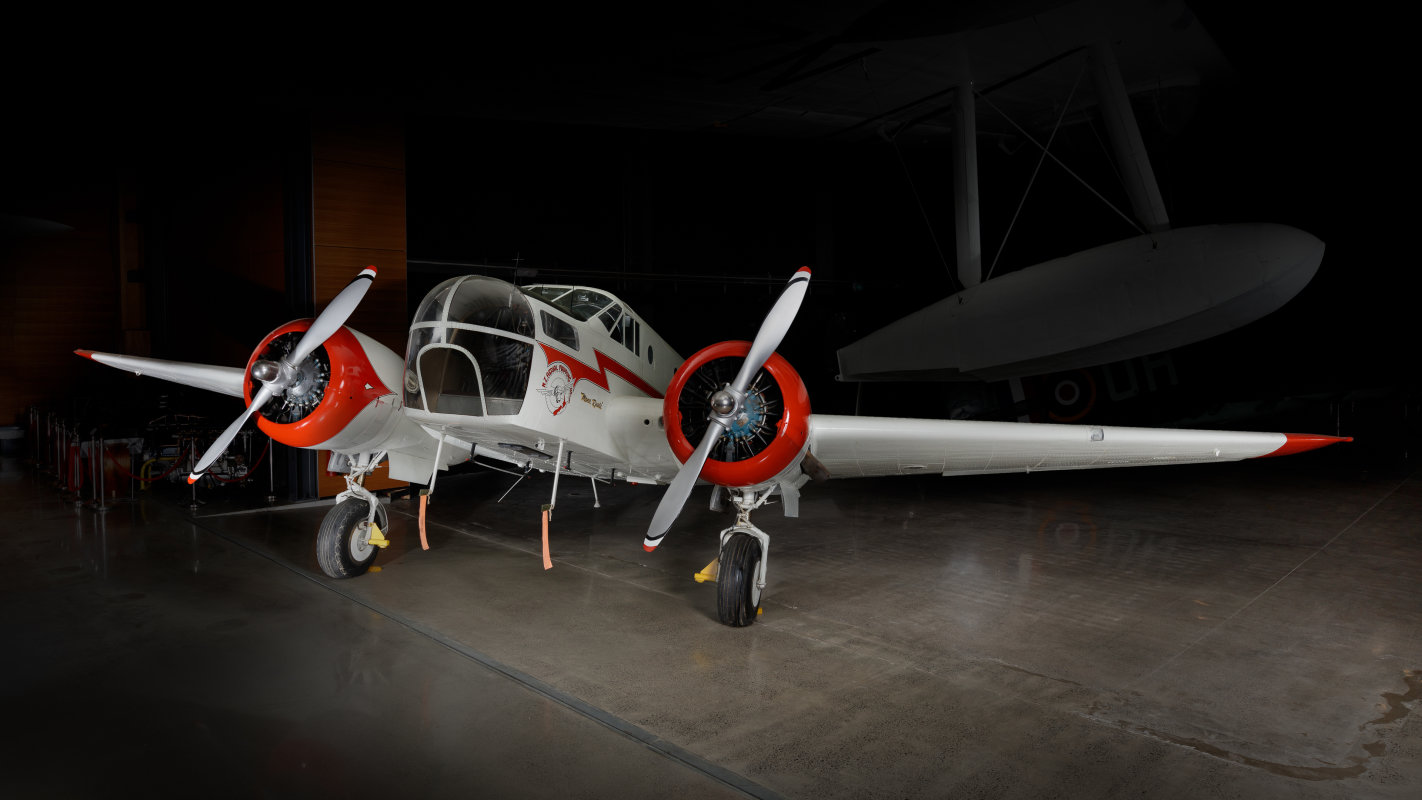
Beechcraft AT-11 Kansan ZK-AHO Manu Ruuri [1982.775] Museum of Transport and Technology (MOTAT).
New Zealand Aerial Mapping played a significant role in advancing the topographical mapping of Aotearoa New Zealand, and its three Wild A8 stereoplotters were key pieces of equipment in turning the aerial survey photographs taken in NZAM’s planes into topographical maps. Digital technology has replaced both the photography and photogrammetry aspects of topographical map production, however, the archive of maps and imagery resulting from NZAM’s activity and that of others in the industry provide important visual evidence of Aotearoa New Zealand’s natural and built landscape, and documentation of changes to the whenua.
New Zealand National Film Unit, An Inch to a Mile (1971)
Story by Nicola Jennings, Senior Curator – Technology (MOTAT)
Story edited by Belinda Nevin, Curatorial Research Manager (MOTAT) and Megan Hutching, Oral Historian (MOTAT)
Citation:
Jennings, Nicola, 2022. Plotting Aotearoa New Zealand - How We Made our Maps. MOTAT Museum of Transport and Technology. Published: 4 November 2022. URL: https://www.motat.nz/collections-and-stories/stories/plotting-aotearoa-new-zealand-how-we-made-our-maps
Objects in the MOTAT Collection:
Wild Heerbrugg A8 725 stereoplotter
Lightbox used with the Wild A8 stereoplotter
Gear set for the Wild A8 stereoplotter
Gear set for the Wild A8 stereoplotter
Beechcraft AT-11 Kansan ZK-AHO
Further reading:
Melanie Lovell-Smith (August 2018). Modern mapping and surveying, Te Ara - the Encyclopedia of New Zealand, http://www.TeAra.govt.nz/en/modern-mapping-and-surveying
Sources
Conly, G. Piet’s Eye in the Sky: The Growth of New Zealand Aerial Mapping. (1986) Grantham House Publishing, Wellington.
Land Information New Zealand Toitū te whenua (November 2014). Guidelines on geo-referencing and orthorectification of historic aerial imagery.https://www.linz.govt.nz/sites/default/files/Georeferencing%2520and%2520orthorectification%2520guidelines%25202014%2520.pdf
Science Direct (n.d) Photogrammetryhttps://www.sciencedirect.com/topics/agricultural-and-biological-sciences/photogrammetry (accessed 12/10/2022)
Stephens, P., van Asch, P. and Clark, M. No Clouds Today. (1991) The Dunmore Press Ltd, Palmerston North.
Conversation with Stewart Hyslop, 2 December 2019, Hastings.